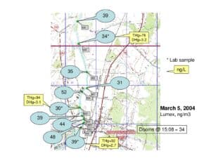
Two map panels showing real-time Lumex mercury vapor measurements (ng/m3) collected along the South River watershed on March 4–5, 2004. Sample locations are labeled with Lumex readings and green site markers; several lab grab samples are annotated with THg and DHg values (ng/L). Locations include Dooms, Waynesboro area, and Crimora.
File Type:
pdf
Categories:
Maps
Publication Date :
2004-03
Type :
Map
Review Notes :
The PDF consists of two map panels labeled March 4 and March 5, 2004 showing Lumex (ng/m3) point readings and yellow callouts with lab sample values listed as THg and DHg (ng/L). No author, agency, or explicit coordinate metadata was visible; lab methods and exact site IDs beyond the map labels are not provided in the document.