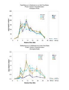
A set of figures from the Phase I System Characterization Ecological Study showing sediment mercury metrics across relative river mile. Plots include total mercury and methylmercury on an ash-free basis, percent of total mercury as methylmercury, and percent KOH-extractable total mercury. Data are shown for multiple months (March–June) and include NR-01 and NR-02 sites.
File Type:
pdf
Categories:
Technical Documents
Publication Date :
Type :
Monitoring Report
Review Notes :
The PDF contains only figures (charts) and no visible publication date or authorship. NR-01 and NR-02 appear as site labels on the plots but their nature (e.g., reference sites) is not stated in the images. No additional metadata or context is present in the file to assign a specific report date or full report title.